
 |
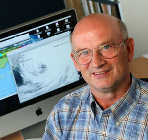
| Storm tracker and adjunct professor Hal Ritchie. (Nick Pearce Photo) |
Bill, Danny and Erika are making up for a slow start to hurricane season. Named storms have been whipping through the alphabet and churning up the Atlantic in recent days.
Just a month ago, weather watchers and emergency managers along the eastern coast of the United States and Canada were expecting a below-normal season due to the calming effects of El Niño.
But, as Prof. Hal Ritchie remarks, it only takes one hurricane to turn a quiet season into a devastating one. He notes Hurricane Andrew was the first named storm and only major hurricane of an otherwise inactive 1992 season; the category-four storm blew through the Bahamas, Florida and south-central Louisiana, leaving death and disaster in its wake.
“We escaped Bill but who knows what will happen with the next one,” says Dr. Ritchie, adjunct professor with the Departments of Oceanography and Physics and Atmospheric Science at Dalhousie and a senior research scientist with Environment Canada.
The good news is that hurricane forecasting is getting better all the time. The forecasts for Bill, for example, were bang on five days in advance of the storm, with predictions that Bill would sweep south of Nova Scotia as a category-one hurricane on Sunday, Aug. 23 and then start to transform into a post-tropical storm.
The maximum winds of 130 km/h blew offshore, passing far enough below the coast to spare Nova Scotians the full force of Bill’s fury. Even with the close call, it seems all people heard was “category one.”
“It’s almost as if people were disappointed,” says Peter Bowyer, program supervisor with the Canadian Hurricane Centre. “But it doesn’t get any better in terms of forecasting. We don’t sensationalize; we just say, ‘here are facts.’”
Hurricane forecasters still rely on good, old-fashioned observations in making predictions about a hurricane’s path and strength. Information about wave heights, temperature, wind direction and velocity and humidity are gathered using fixed weather buoys and buoys that travel with currents. Radiosondes, balloon-borne sensors that measure conditions in the upper atmosphere, collect data on temperature, humidity, pressure, wind speed and direction. Details on cloud formation and infrared radiation are noted using new-fashioned satellites.
One of the crucial indicators for hurricane prediction is sea surface temperature. The warmer the sea surface temperature, the more intense the hurricanes. As a hurricane builds up energy, it feeds off heat from the water. As water releases more water vapour into the air. As water vapour rises, it cools, condenses into rain, and releases heat that fuels the hurricane. The higher the vapour rises, the more heat is released, and the more intense the storm.
Observations, such as sea surface temperature, are fed into numerical models in the production of weather forecasts. “Having a representation of the atmosphere at one time, we can step it ahead, a day or a week, to make predictions about the future,” explains Dr. Ritchie.
And that’s not all: forecasts from different centres around the world are then melded together and result in a consensus approach. The statistical combination of many forecasts acts to smooth out errors in forecasts and observations to create “the most likely analysis,” says Dr. Ritchie.
Even with the accuracy of reports, the idea is to “prepare for the worst and hope for the best.” Nova Scotians have an idea of what to expect, having been hit by one or two dangerous tropical storms every year since 2000.
Kyle struck the south coast of Nova Scotia last year, Gustav pounded southern Cape Breton in 2002 and Hortense took a similar path to Bill in 1996, making landfall along Nova Scotia’s eastern shore.
Of course, the most memorable is Hurricane Juan in 2003; the category-two hurricane ripped through Nova Scotia, Prince Edward Island and parts of New Brunswick causing $100 million in damage.
“The general public may have expected something more extreme (than Bill) with memories of Juan still fresh,” says Dr. Ritchie. “It certainly felt similar the night before, with that warm tropical air coming in advance.”
Comments
comments powered by Disqus